Miscelleneous

What is AIS or Automatic Identification System ?

Written by Amit Sharma

AIS-  Stands for Automatic Identification System

Automatic-  No human Intervention once the system is set and gets going.

Identification-  Identification of the other ships which are also operating the AIS.

System- Your AIS is a part of system which includes your ship, ships around you who are also operating AIS, VTS and various Navigational subsystems like GPS, Log, Gyro etc.

What is the use of AIS?

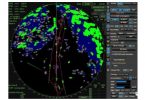
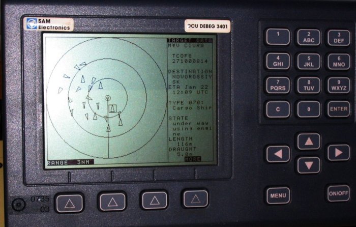
It helps a vessel’s watch keeping officer and the VTS to Identify and monitor movement of vessels in the vicinity. In this system, a ship exchanges data like —Her identity, Position, Course, and Speed electronically with other nearby ships and VTS stations. The same data received form other is displayed on a screen in the wheel house for the benefit of the officer of the watch.The IMO requires AIS to be fitted aboard international voyaging ships with GT of 300 or more and all passenger ships regardless of size. It is estimated that more than 40,000 ships currently carry AIS class A equipment.

How did the need  of AIS arise? / Why do we need AIS ?
  • OOW has to continuously watch out against the danger of collision.
  • The OOW continuously monitors movements of ships around to avoid close quarter situation.
  • He uses visual, aural or electronic means to carry out this monitoring.
  • Such monitoring becomes inadequate if movement and intention of another vessel are unclear.
  • It then becomes very critical to communicate with such a ship.
  • With number of ships in the vicinity, confusion about a ships identity can be dangerous.
  • The need to positively identify a ship has became more urgent because of presence of faster and larger ships, increasing traffic density and zero tolerance for pollution which invariably occurs after a collision.
  • AIS provided the solution for easy identification.
How does AIS work? / What is principle of operation of AIS?

AIS consists of 1xVHF transmitter, 2xVHF TDMA receivers, 1xVHF (DSC) receiver, and internal links to ships Gyrocompass, GPS & ship’s log.
AIS transmitter automatically broadcasts information about ships position, COG, SOG and CPA/TCPA at regular intervals on two VHF Maritime Frequencies of 161.975 Mhz & 162.025 Mhz.
AIS  gleans this data from ship’s GPS and Gyrocompass.
The AIS transmitter also transmits static information like ships identity, IMO Number, her cargo, her destination etc which is manually inputted during installation and at the beginning of the voyage.
Ships in the vicinity with AIS transmit their own information during their own time slots, which are so allotted that there is never any interference between two transmission.
This is achieved by using a patented STDMA technology which does continuous synchronization of all AIS stations in the area.

AIS Display

When not transmitting, AIS receiver receives information being transmitted by other ships and displays them on the AIS screen.
AIS display


If the AIS is connected to ships Radar or ECDIS, the received information can also be shown on the PPI and the electronic chart.  This information can also be shown if the IA screen or chart plotter, showing the other vessels’ positions in much the same manner as a radar display.

AIS DATA MANAGEMENT

STATIC DATA (has to be entered by ship staff)

  • IMO Number (The vessel’s Maritime Mobile Service Identity (MMSI) – a unique 9-nine digit identification number.
  • Call Sign (upto 7 digits) & Name (upto 20 characters)
  • Length and Beam
  • Type of Ship & Cargo
  • Antenna Location on a ship

DYNAMIC DATA (auto updated from gps/gyro etc)

  •  Ships Position (in Lat & Long) with positional accuracy of 1/10,000th of a minute.
  • Time In UTC accurate to nearest second when this data was generated
  • Course Over Ground (upto one decimal place accuracy)
  • Speed Over Ground 0 to 102 knots
  • Heading
  • Rate of Turn (Where Fitted) right or left, 0 to 720 degrees per minute
  • CPA/TCPA

VOYAGE RELATED DATA (to be entered by ship staff)

  • Ships Draft (0.1 meter to 25.5 meters)
  • Hazardous Cargo
  • ETA (UTC) & Destination (Max. 20 characters)
  • Route

SAFETY RELATED MESSAGES (entered by ship staff)

Updating of Data

Dynamic

  • At Anchor — every 6 minutes
  • Underway –
    • 0-14 kts -every 12 secs /4 secs when a/c
    • 14-23 kts – every 6 secs /2 secs when a/c
    • >23 kts – every 3 secs /2secs when a/c
  • Static/Voyage Data: Every 6 minutes or whenever amended
  • Safety Messages: As and when required.

TO UNDERSTAND BETTER, PLEASE WATCH THIS VIDEO  

AMIT KUMAR
Related Searches
  1. What are objectives of AIS?
  2. What are advantages / limitations of AIS?
  3. What does AIS range mean?
  4. What are applications of AIS?
  5. What are Channels for AIS ?
  6. What is AIS requirements for NON SOLAS ships/ vessel?
  7. What is IMO performance standard requirement for AIS?
  8. What is SOLAS regulation/requirement for carriage of AIS?

About the author

Amit Sharma

Graduated from M.E.R.I. Mumbai (Mumbai University), After a brief sailing founded this website with the idea to bring the maritime education online which must be free and available for all at all times and to find basic solutions that are of extreme importance to a seafarer by our innovative ideas.

Leave a Comment