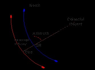
Since it is impractical to draw the large circle of a position circle on the chart, only the part of it in the vicinity of the ship that is perpendicular to the bearing of the body from the ship is drawn. When observing a celestial body, we can obtain its azimuth and altitude.
As long as the altitude is corrected, the observed zenith distance is the true zenith distance, which is called Observed Zenith Distance or True Zenith Distance.
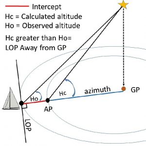
With the D.R. position of the observer at the time of observing, the altitude can be calculated to obtain the zenith distance, which is called Calculated Zenith Distance.
The difference between the observer or true zenith distance and the calculated zenith distance is the intercept.
| If the true zenith distance is smaller than the calculated zenith distance, then the observer is nearer toward the geographical position of the celestial body compared with the DR position, and the intercept is called TOWARD. | If the true zenith distance is greater than calculated zenith distance, then the observer is further away from the geographical position of the celestial body compared with the DR position, and the intercept is called AWAY. |
 In other words we can explain intercept method as:
In the Marc St. Hilaire Method we calculate what the altitude of a heavenly body, the sun, moon, planet or fixed star should be at a given instant, if seen from the assumed ship’s position by Dead Reckoning.
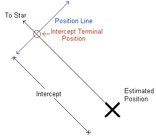
An altitude of the heavenly body is measured with the sextant, corrected for dip, refraction, etc., in the usual way, and the true altitude found. Unless the Dead Reckoning is correct, there will be a difference between the calculated and the true altitudes. This is called Altitude Difference or Intercept, and provides us with co-ordinates or, in other words, lines which are the means for finding the ship’s correct position.
General Rules
Marc St. Hilaire Method may be used at any time, but owing to the more rapid change in azimuth of the heavenly bodies when on or near the meridian, the best results are obtained when the object is, say 20° or more from the meridian. If the object is on the meridian use D. R. Latitude and Declination, and if near the meridian, use also the ex-meridian augmentation in computing the zenith distance and hence the calculated altitude.
Rules for Solar Observations
We require :
- The sun’s westerly hour angle (t), which is the ship’s astronomical apparent time.
- The latitude of ship.
- The sun’s declination.
- Latitude difference declination (Lat. 1 DecL).
- Equation of time.
- True altitude.
- True azimuth.

It was very help full. .