What is a Baseline?
A baseline is a legal construct:
A boundary line that determines where a State’s maritime sovereignty and jurisdiction begins and ends. In fact, baselines determine all areas of maritime jurisdiction. They create a demarcation between areas where a State has no rights and those where a State does enjoy rights. We should now note that the default baseline under UNCLOS is the normal baseline. According to Article 5 of UNCLOS, a normal baseline is drawn at the low-water line, as stated in official charts. Perhaps the easiest way to think of a normal baseline is as an “outline” of a State’s coast. Waters on the landward side of a baseline are considered a State’s internal waters, treated much in the way that land would be treated. However, in some situations, it is either impractical or uneconomical to draw a normal baseline. In such cases, straight baselines are used in lieu of normal baselines.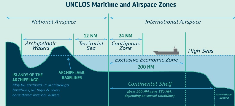
The limits of maritime zones recognized under international law are officially depicted on National Oceanic and Atmospheric Administration (NOAA) nautical charts, and several are also (unofficially) displayed in the Marine Cadastre, which is a partnership effort between NOAA and the Bureau of Ocean Energy Management (BOEM). NOAA, with the consensus of the interagency U.S. Baseline Committee, develops the limits of maritime zones using standards and concepts consistent with international and U.S. law, including