Plane sailing solves problems involving a single course and distance, difference of latitude, and departure, in which the Earth is regarded as a plane surface.
This method, therefore, provides solution for latitude of the point of arrival, but not for longitude. To calculate the longitude, the spherical sailings are necessary.
Plane sailing is not intended for distances of more than a few hundred miles.
Since the track is cutting all meridians at the same angle, Plane Sailing is also one of the methods of Rhumb Line Sailing. In a short distance, a rhumb line appears as straight line, but the track is actually a curve and, if extended, it will eventually spiral in on the North or South Pole. Because the unit of latitude is not the same as the unit of longitude, the difference of longitude has to be calculated to become departure, which is expressed as a latitude unit.
PLANE SAILING: DEPARTURE = (D’LONG X COS M LAT DEP)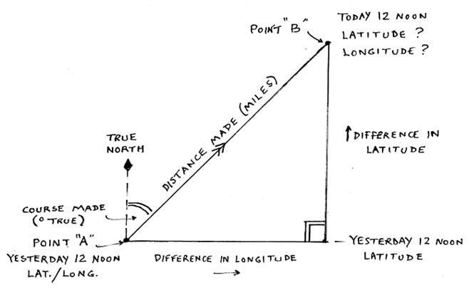
Parallel sailing is the interconversion of departure and difference of longitude when a vessel is proceeding due east or due west.
PARALLEL SAILING: DEPARTURE =(D’LONG X COS LAT D’ LONG)
Mercator sailing provides a mathematical solution of the plot as made on a Mercator chart. It is similar to plane sailing, but uses meridional difference and difference of longitude in place of difference of latitude and departure.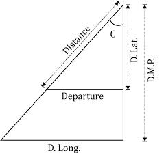
Find course & Distance:
TAN CO = (D’LONG /DMP D’LAT)
DIST. = (D’LAT / COS CO)
Find Arrival Postion:
D’LAT = (DIST X COS CO)
D’LONG = (TAN CO X DMP)
Great circle sailing involves the solution of courses, distances, and points along a great circle between two points.
Great Circle Sailing is used for long ocean passages. For this purpose, the earth is considered a perfect spherical shape; therefore, the shortest distance between two points on its surface is the arc of the great circle containing two points. As the track is the circle, so the course is constantly changing, and the track must be broken down into a series of short rhumb lines at frequent intervals that can be used to sail on the Mercator chart. Doing this, the navigator would use the Gnomonic charts combined with the Mercator charts to draw the sailing track.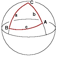
Find Dist:
COS AB = (COS PA X COS PB) + (SIN PA X SIN PB X COS P)
Find Initial Course:
( COS PB – COS AB X COS PA)
COS A = ———————————–
( SIN AB X SIN PA)
Find Final Course:
( COS PA – COS AB) X ( COS PB)
COS B = ————————————–
(SIN AB X SIN PB)
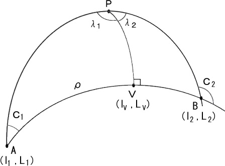 The initial course always has same name as the initial latitude and east or west direction of the course. The final course always has the opposite name from final latitude unless initial position and final position are in different hemispheres, when the final will have same name as final latitude and east or west direction of the course.
Note :
Traverse sailing combines the plane sailing solutions when there are two or more courses and determines the equivalent course and distance made good by a vessel steaming along a series of rhumb lines.
Middle- (or mid-) latitude sailing uses the mean latitude for converting departure to difference of longitude when the course is not due east or due west.
Middle-latitude sailing combines plane sailing and parallel sailing. Plane sailing is used to find difference of latitude and departure when course and distance are known, or vice versa. Parallel sailing is used to interconvert departure and difference of longitude.
Composite Sailing
When the great circle would carry a vessel to a higher latitude than desired, a modification of great circle sailing called composite sailing may be used to good advantage.
The composite track consists of a great circle from the point of departure and tangent to the limiting parallel, a course line along the parallel, and a great circle tangent to thelimiting parallel and through the destination.