Convection
When a parcel of air gets heated due to any local cause, it expands, becomes less dense than surrounding air, and rises. This is called a convention current. This local heating can be caused by contact with warm sea or ground. So long as the parcel is warmer that the surrounding air at each level, it will continue to rise (unstable condition of air).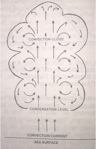
During this ascent, the rising air cools adiabatically and when cooled below dew point, condensation takes place resulting in convention clouds that are always of the cumulus type. That is why a large island (more than about 10 miles long) in mid ocean may be seen to have a stationary cumulus cloud above it during daytime. Actually the cloud is continuously forming from below and dissipating to leeward. It is for the same reason that during daytime, the coastline of a large landmass may have a long line of cumulus cloud above it, parallel to the coast, though there may be no other clouds to windward.
The greater the ascent of the air, the greater the vertical extent of the cloud- as the air ascends more and more, it gets progressively cooled further and the excess moisture gets condensed into more and more cloud, resulting in great vertical extent of the cloud- towering cumulus.
If the ascent is very rapid, cumulonimbus cloud may form with its head well into high cloud level until it reaches the tropopause, beyond which convention currents cannot rise. The top of the cloud then spreads sideways, resembling an anvil. This is called anvil-shaped cumulonimbus. Actually the anvil consists of ice crystals and is a cirrus cloud.
Over land, cumulus clouds generally begin to form in the morning after sunrise, reach their maximum quantity around late afternoon, when the land temperature is at its highest, and begin to dissipate after sunset as the land cools.
Over sea, there is little change of air temperature during day and night and hence cloud development is very little. However clouds may develop over sea at night due to cooling caused by radiation of heat into space, by the upper layers of air. Cloud development over sea, therefore, is opposite in time to that over land- over land it forms during day and dissipates at night whereas over sea, the opposite happens.