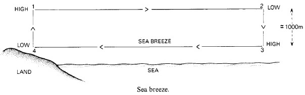
The seafarer frequently encounters local wind conditions in coastal waters which is the result of large difference in diurnal range of atmospheric temperature over land and over sea.
Over land, the diurnal range may be as high as 20˚C whereas over sea, it is less than 1˚C.
SEA BREEZE
During the day, the land surface temperature increases more rapidly than that of the sea surface. Air above the land becomes hot and the vertical motion of the air through convection modifies the pressure gradient. Hence the pressure above the land becomes lower than that over the sea as the temperature of the sea surface and the air above it remains fairly constant resulting in high pressure over sea so the air moves towards lower pressure (land). Thus during the day, a sea breeze blows onshore, which may be felt for some distance inland, and an offshore wind blows at some 1000 meters above the sea. The sea breeze gradually increases in speed as the land surface temperature increases, and reaches a maximum by mid-afternoon & dies down about sunset. When the sky is clear a large amount of solar radiation reaches the surface and the wind speed will be at its maximum (midlatitudes- Force 3; low latitudes-Force 5).