Katabatic winds develop at night when there are clear skies, a general slack pressure gradient, and rapid radiative cooling of the land. The air at X adjacent to the slope, becoming cooler and therefore denser than the air which is further away at the same level (Y), starts sliding down because of the gravitational force forming the katabatic wind (in Greek ‘kata’ means down and ‘biano’ means to move. On reaching the foot of the slope the wind moves out to sea. Adiabatic warming of the air during descent is counteracted by conduction as it is in continuous contact with the colder mountain slope. When the slope is covered with ice or snow, which are effective insulators, very limited conduction takes place between the slope and the upper surface of the ice or snow cover. Thus during the cooling period overnight the upper surface experiences a more rapid decrease in temperature than that of a bare slope. Under such conditions, the adjacent air, becoming very cold and dense, descends at a speed which can reach gale force conditions.
Katabatic (downslope) winds affect sea conditions off mountainous coastal areas, particularly the Norwegian fjords and the ice covered regions of Greenland and Antarctica.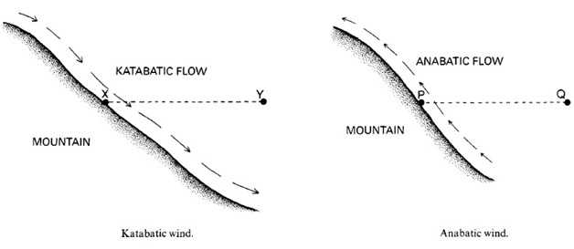
During the day an anabatic wind develops. With clear skies the slope absorbs solar radiation and heats the air (P) directly in contact. This air then flows up the slope, as it is at a higher temperature than the air (Q) further away at the same level. The air moving up the slope is subject to expansion and therefore cooling. The contact maintained with the warm slope ensures its continued ascent, with a maximum speed during mid-afternoon. Anabatic winds occur in the Alps in summer months when there is generally a slack pressure gradient.