The rules in this chapter apply to all ships above 24 m in length, except for ships of war, pleasure yachts not engaged in trade and fishing vessels. The requirements are in compliance with the Protocol of 1988 relating to the International Convention on Load Lines 1966 (ICLL).
A load line, also called Plimsoll mark, is a marking indicating the extent to which the weight of a load may safely submerge a ship, by way of a waterline limit.
It is positioned amidships on both sides of a vessel’s hull and indicates the draft of the ship and the legal limit to which a ship may be loaded for specific geographical areas and seasons of the year.
PURPOSE OF LOADLINE
The purpose of the load line is to ensure that a ship has sufficient freeboard (the height from the waterline to the main deck) and thus sufficient reserve buoyancy (volume of ship above the waterline). It should also ensure adequate stability and avoid excessive stress on the ship’s hull as a result of overloading. Ships intended for the carriage of timber deck cargo are assigned a smaller freeboard as the deck cargo provides protection against the impact of waves.
The exact location of the load line markings is calculated and/or verified by a classification society, which then issues a load line certificate.
The first international convention on load lines was adopted in 1930. It was based on the principle of reserve buoyancy. In 1966 the IMO adopted a new convention, determining the freeboard of ships by subdivision and damage stability calculations. The International Convention on Load Lines 1966 applies to all vessels engaged in international trade and determines the permitted draft/freeboard for a vessel in different climate zones and seasons, which are defined in a special international load line zones and areas map.
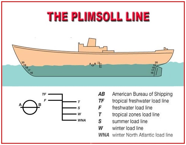
The various markings on the images have the following meaning.
- Deck Line – this is the line shown on top which is 300 mm long and 25 mm thick (infact all lines are of equal thickness of 25mm) and it denotes the level of the freeboard deck.
- The circular symbol with a line passing through it in the middle is directly below the deck line.
- Summer Load Line – this is the line marked “S” and is in line with the center of the disc. It denotes the depth to which the ship can be loaded when it is floating in salt water in the summer zone.
- Fresh Water Load Line – this is the line upto which the ship can be loaded in fresh water in the summer zone. It must be noted that when a ship loaded to “F” in fresh water goes into salt water it automatically comes to the “S” level.
- W and WNA refer to Winter and Winter North Atlantic lines respectively for loading in winter zone
- TF and T refer to the tropical fresh water line and tropical fresh water line respectively.

Hi,
what are FT and AT stand for in freeboard calculation?
Why loadline mark both side is given what was the reason
Because a ship can go either side alongside . Visual readings are required by mates loading vessel to its max respective loadine and for inspectors to ascertain whether a ship is overloaded or not .
because ship can list to any side during cargo operations & appropriate reading will not be possible then.
What is loadline zone??
LL zone are particular area which falls under load line….. Zone can be seen in routing charts .,..