Front is the transition zone between air masses with distinctly different properties.
The differences in density are most often caused by temperature differences. Separate air masses with different humidities as well. We identify fronts by the movement of this transition zone and the properties that move over a geographical location.
How do you identify a front on a surface weather map or by your own weather observations? Look for:
- Sharp temperature changes over a relatively short distance
- Change in moisture content
- Rapid shifts in wind direction
- Pressure changes
- Clouds and precipitation patterns
Types of Fronts:
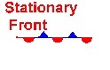 A stationary front is characterized by no movement of the transition zone between two air masses.
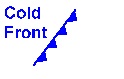 A cold front is cold air displacing warm air.
Steep leading edge — friction slows surface advance, moves quickly–25 knts up to 40 knts faster=steeper
General weather characteristics of a Cold Front Weather Feature Before Frontal Passage Region of Front After Frontal Passage Winds S-SW gusty W-NW Temperature Warm Sudden decrease Steady Cooling Dew Point high; remains steady Steady Decreases Pressure Falling steadily Minimum; rapid rise steady rise Visibility Fair to Poor Poor then improving good Clouds Ci, Cs Cb Cb Cu Precipitation showers heavy precip. clearing
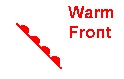 warm front is warm air displacing cool air diagram. Shallow leading edge warm air must “overrun” cold air–cold air recedes moves slow 10-15 knts.
 There are two kinds of occluded fronts
Cold occlusion-cold front catches up with warm front. Ns, Tcu, Cb warm very cold .
Warm occlusion mostly in NW. Warm cool mP off ocean cold cP warm occlusion.-+
Precipitation is similar to the cold occlusion.

Leave a Comment