Mercator projection is the method by which the curved surface of the Earth has been drawn on a flat sheet of paper. There are other projections, which you will come across, in most cases they will have little effect on the way you use the chart.
If you imagine a cylindrical screen around the Earth. Then project a line from the Earth’s center, through its surface on to the screen so that the features on the surface are projected on to the screen. When this screen is opened up and rolled out flat you have the chart that we use to navigate on.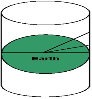
This will give you an idea of how Mercator Projection works.
With any chart projection there is some distortion created, the major consequence of Mercator projection is that the further north you travel, the divisions for latitude on the chart will become longer. This is of little practical consequence unless you are planning passages greater than 600 miles in length.
To demonstrate this, measure the distance between the 5′ and 10′ marks on the bottom right hand side of Chart 1. Now go to the top right hand side of the chart and compare this distance with the 5′ between 20′ and 25′.