Fohn wind effect is an effect whereby the leeward side of a mountain range is drier and warmer than the windward side. This would be more pronounced if the windside side. This would be more pronounced if the wind was blowing from the sea towards a coastal mountain range, as the air would then be moist. Fohn wind effect is the direct result of the difference between the DALR and the SALR of air as illustrated below:
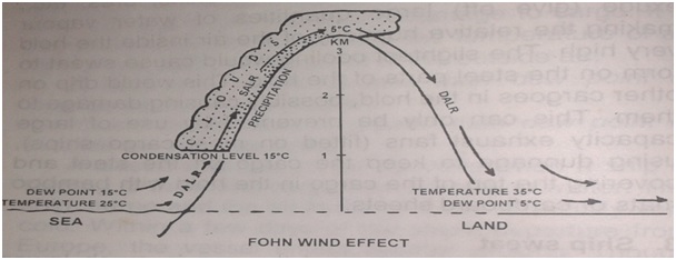
Imagine an onshore breeze, of 25°C temperature and 15°C dew point, blowing against a mountain range 3 km high.
This on shore breeze begins to ascend and its temperature drops by 10°C per km height (DALR). On reaching a height of 1 km, the temperature of the air has fallen to 15°C, which is also its dew point. The air is then saturated. On ascending further the temperature drops by about 5°C per km height (SALR). The excess moisture in the air is given off as orographic cloud and then heavy rain falls on the windward side. On reaching the top, the air will still be saturated and its temperature would be about 5°C. while descending on the leeward side, the temperature of the air would increase at 10°C /km (DALR). This is because, once the temperature of the air begins to rise even by a small amount, the air is not saturated any more. On reaching sea level on the leeward side, the temperature of air would have increased to 35°C. since the same air was saturated at 5°C and no water vapour has been let in or taken out, the dew point of the descending air would be 5°C. Comparing the temperature and dew point on the windward side (temperature 25°C, dew point 5°C), it is clear that the leeward side is warmer and drier than the windward side. It is also clear that heavy precipitation occurs only on the windward side and no precipitation occurs on the leeward side, which is hence referred to as the ‘rain shadow area’ of the mountain range.