Doubling the Angle on the Bow
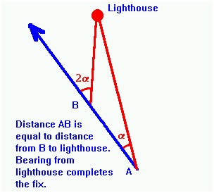
As we know that the angle on the bow when the first bearing is taken is 35°. The time of this bearing is noted and the bearing then carefully watched until the angle on the bow doubles to 70°. The triangle formed by the two position lines and the course line is isosceles, therefore the range at the time of the second bearing is equal to the distance run between bearings.
The Four-Point Bearing
This is a further refinement of the running fix in which the first bearing is taken when the object is at four points (45°) on the bow. When the object is on the beam the range will be the same as the distance run since the first bearing was taken. The disadvantage of the four point bearing is that the range of the single object is not known until it is abeam. This is of little help in passing at a safe distance.
The Transit Bearing
When two charted objects come into line they are said to be in transit. It has already been shown how a transit can be used to check the compass error. A transit can also be used to obtain a fix in conjunction with another position line such as a range (or be used to obtain a fix in conjunction with another position line such as a range (or even a sounding) without use of the compass.
Danger or Clearing Bearings
Many ports have provided leading lights or shapes to guide mariners safely into harbour, avoiding shoals and other dangers.
In places where such aids are not provided, the navigator may still be able to select a leading line provided by the transit of natural features. Thus approaching an anchorage with a coastal hill in transit with a more distant peak may ensure that the vessel clears dangerous rocks.
The advantage of a transit is that the mariner is assured of a safe approach regardless of any compass error
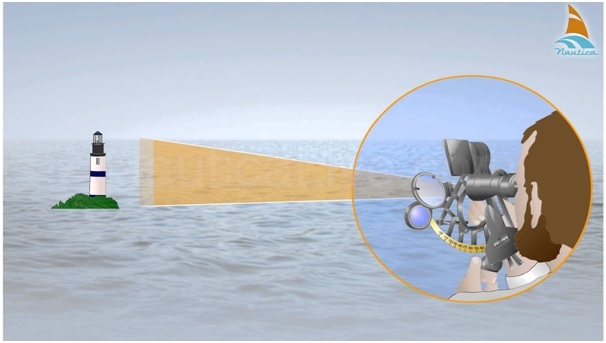
Vertical Sextant Angle
The distance off a light can be found by taking the vertical angle the light subtends at the vessel above sea level.
By Astronomical object
Six common methods are used :
- Latitude by Polaris (Pole Star)
- Latitude by meridian altitude
- Latitude by ex-meridian
- Longitude by meridian passage of the sun
- Longitude by chronometer
- Intercept
Latitude by Polaris (Pole Star)
As the Pole Star is always around the North Pole at radius of 1°, so it is always on or near the meridian passage. The latitude of the observer can be determined. The position line runs in an east-west, or nearly east-west, direction.
Latitude by Meridian Altitude
This method is used to obtain the position line by taking the altitude of the celestial body when it is instantly on the same meridian as the observer’s. In this case, the position line runs in an east-west direction (90°-270°), and coincides with a parallel of latitude.
Latitude by Ex- Meridian Altitude
It is sometimes not possible to obtain the altitude of the celestial body when it is on same observer’s meridian due to cloud, environmental factors, etc. If the altitude of the celestial body can be obtained a few minutes before or after meridian passage, the Ex-Meridian method can be used to reduce the observed altitude to meridian altitude. The latitude of the observer can be determined. The position line runs nearly in an east-west direction.
Longitude by Meridian Passage of the Sun
By knowing that the sun orbits with one completed circle in 24 hours, or 15° for every hour, the observer can determine position at noon by using the chronometer. The advantage of this method is that the DR position is not required.
Longitude by Chronometer
This method is also used to determine the longitude of the observer. The position line runs through the position at DR latitude and observed longitude in a direction perpendicular to the azimuth of the celestial body from the observer.
Intercept
Since it is impractical to draw the large circle of a position circle on the chart, only the part of it in the vicinity of the ship that is perpendicular to the bearing of the body from the ship is drawn. When observing a celestial body, we can obtain its azimuth and altitude. The azimuth is the bearing of the body and the altitude of the body, giving us the zenith distance. As long as the altitude is corrected, the observed zenith distance is the true zenith distance, which is called Observed Zenith Distance or True Zenith Distance. With the D.R. position of the observer at the time of observing, the altitude can be calculated to obtain the zenith distance, which is called Calculated Zenith Distance. The difference between the observer or true zenith distance and the calculated zenith distance is the intercept.
If the true zenith distance is smaller than the calculated zenith distance, then the observer is nearer toward the geographical position of the celestial body compared with the DR position, and the intercept is called TOWARD.
If the true zenith distance is greater than calculated zenith distance, then the observer is further away from the geographical position of the celestial body compared with the DR position, and the intercept is called AWAY.

good material for learning.